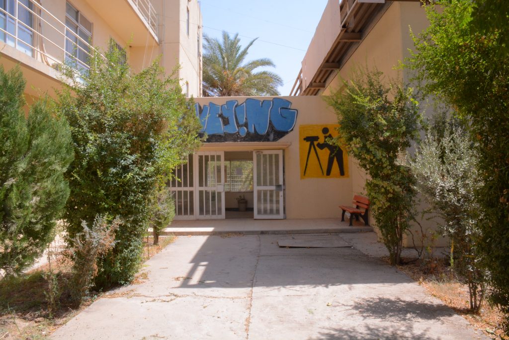
Geomatics (Surveying) Engineering
is one of the main departments in the college of engineering at University of Salahaddin. It has been established on September 2009. Geomatics engineering is the modern term for surveying engineering, which is considered as a rapidly developing engineering discipline that focuses on spatial information. The given courses in this engineering branch will provide the student the ability for gathering, measuring, and archiving geospatial data for the earth from ground or space.
Geomaticions plays an important role in different engineering fields either in mapping or construction. For instance, the careers that Geomatics engineer can be involved are: mapping, urban planning, land surveying, satellite image processing, GIS Analysis and map production, and others. The studying in this branch will be over four academic years, afterward the graduated student will get a Bachelor of Science (BSc) degree in Geomatics (Surveying) engineering from College of Engineering – University of Salahaddin.
Mission
In 2009, the Department developed a mission statement to present our aims through maintain world class undergraduate and graduate training of highly skilled engineers in order to be cable to fulfil the of regional, national and international requirements. It is also grantee that the graduated student from our department is well educated and are able to operate effectively and professionally within the public and private constructions sector and full fill its needs. Also, to keep and continue research area within standard disciplines, and cooperate with international level for teaching and research that our resources permit
Vision
provide high quality Technological Education and Training, Research, Professional Services and Innovation in the field of mapping, planning and analyzing geospatial data.

Dr.Danar Hassan Ghalib Talabani
Head of department
Geomatics is a field that incorporates several others such as the older field of land surveying engineering along with many other aspects of spatial data management ranging from data science and cartography to geography. Following the advanced developments in digital data processing, the nature of the tasks required of the professional land surveyor has evolved significantly in recent years. As our societies become more complex, information with a spatial position associated with it becomes more critical to decision-making, both from a personal and a business perspective, and also from a community and a large-scale governmental viewpoint.
Geomatics engineers utilize a wide range of technologically advanced tools such as digital theodolite/distance meter total stations, Global Positioning System (GPS) equipment, digital aerial imagery (both satellite and air-borne), and computer-based geographic information systems (GIS). These tools enable the geomatics engineer to gather, process, analyze, visualize and manage spatially related information to solve a wide range of technical and societal problems.
The aim of geomatics engineering is; the development and use of various spatial techniques based on modern technology to better understand, plan, organize, monitor and manage the earth we live in, the production of various maps and spatial data / information for the needs of the country (planning, property, defense etc.) and determining precise position (horizontal and vertical) of any kind of space or land related to the earth.
+9647504845451
News & Activitis
Department of Geomatics (Surveying) Engineering
List of all Study program modules (core Modules) 2023-2024
|
No |
Module Code |
Module Name (course, subject) |
Core/ Elective |
Hours/week |
ECTS Credits |
Prerequisite (Code only) |
Recommended Semester (1,2,3,4,5,6,7,8) | |||
|
Lecture |
Practical |
Tutorial |
Lecturer name |
|||||||
| 1 | 101 | General English I | Core | 5 | M. Sanaa Youssif | |||||
| 2 | 103 | Information Technology | Core | 5 | Dr. Ashty Othman | |||||
| 3 | 102 | General English II | Core | 5 | M. Sanaa Youssif | |||||
| 4 | 104 | Academic Debate | Core | 5 | Dr. Ashty Othman | |||||
| 5 | 105 | Kurdology | Core | 4 | M. Payman | |||||
| 6 | 107 | Math-I(Engineering | Core | 3 | 1 | 5 | M. Hassan Mohammed | 1 | ||
| Mathematics- I) | ||||||||||
| 7 | 7106 |
Fundamental of Surveying Engineering |
Core | 3 | 3 | 6 | M. Baxtiyar Ahmed | 1 | ||
| 8 | 7108 | Engineering Statistics | Core | 4 | 4 | Dr. Ashty Othman | 2 | |||
|
9 |
7109 |
Plane Surveying |
Core |
3 |
3 |
6 |
7106-Fundamental of |
M. Baxtiyar Ahmed |
2 |
|
| Surveying Engineering | ||||||||||
| 10 | 108 | Math-II(Engineering | Core | 3 | 1 | 5 | 0107-Math-I | M. Hassan Mohammed | 2 | |
| Mathematics-II) | ||||||||||
| 11 | 106 | Eng. Drawing | Core | 1 | 3 | 3 | M. Rojgar Qarani | 2 | ||
| 12 | 7114 | Eng. Surveying | Core | 3 | 3 | 6 | 7109-Plane Surveying | M. Ahmed | 3 | |
|
13 |
7115 |
Theory of errors |
Core |
4 |
5 |
Dr. Mohammed Anwer |
3 |
|||
| 14 | 7116 | Map projections | Core | 3 | 5 | Dr. Haval Abduljabar | 3 | |||
| 15 | 109 | Math-III(Engineering | Core | 3 | 1 | 5 | 0108-Math-II | Dr. Danar Ghalib | 3 | |
| Mathematics-III) | ||||||||||
| 16 | 7121 | Eng. Surveying Network | Core | 3 | 3 | 6 | 7114-Eng. Surveying | M. Ahmed | 4 | |
| 17 | 110 | Math-IV (Engineering | Core | 3 | 1 | 5 | 0109-Math-III | Dr. Danar Ghalib | 4 | |
| Mathematics) | ||||||||||
| 18 | 7125 | Cartography | Core | 2 | 2 | 5 | M. Hassan Mohammed | 6 | ||
| 19 | 7148 | Digital mapping | Core | 2 | 2 | 5 | Dr. Dleen Mohammed | 6 | ||
| 20 | 7128 | Construction Surveying & CAD | Core | 2 | 3 | 5 | M. Azad Arshad | 5 | ||
| 21 | 7129 | Photogrammetry | Core | 2 | 3 | 5 | Dr. Haval Abduljabar | 5 | ||
| 22 | 7130 | Global Geodesy | Core | 3 | 5 | M. Baxtiyar Ahmed | 5 | |||
| 23 | 7131 | Adjustment Theory | Core | 4 | 5 | Dr. Mohammed Anwer | 5 | |||
| 24 | 7132 | Engineering Analysis | Core | 4 | 5 | 0110-Math-IV | Dr. Kameran Kakel | 5 | ||
| 25 | 7137 | GNSS | Core | 2 | 3 | 5 | M. Rojgar Qarani | 7 | ||
| 26 | 7138 | Engineering Management | Core | 4 | 5 | Dr. Kameran Kakel | 7 | |||
|
27 |
7141 |
Geographic Information Systems (GIS) |
Core |
2 |
3 |
5 |
M. Hassan Mohammed |
6 |
||
| 28 | 7142 | Remote Sensing | Core | 2 | 3 | 5 | Dr. Dleen Mohammed | 7 | ||
| 29 | 7146 | Engineering Project | Core | 12 | 8 | |||||
| 30 | 7147 | Internships | Core | 18 | 8 |
Bologna study modules (Elective Modules)2023-2024
|
No |
Code |
Module Name (course, subject) |
Core/ Elective |
Hours/week | ECTS Credits |
Prerequisite (Code only) |
Recommended Semester (1,2,3,4,5,6,7,8) |
|||
|
Lecture |
Practical |
Tutorial |
lecture name |
|||||||
| 1 | 7111 | Engineering Geology | Elective | 2 | 5 | M. Hisham Khalil | 2 | |||
| 2 | 7112 | Programming Language C++ | Elective | 3 | 5 | Dr. Haval Abduljabar | 4 | |||
| 3 | 7118 | CAD | Elective | 3 | 5 | Dr. Danar Ghalib | 3 | |||
| 4 | 7119 | Physics for Engineering | Elective | 2 | 5 | M. Hoshang Jaafer | 3 | |||
| 5 | 7120 | Land Law | Elective | 2 | 5 | M. Azad Arshed | 3 | |||
| 6 | 7122 | Cadastral Surveying | Elective | 2 | 5 | M. Azad Arshed | 4 | |||
| 7 | 7123 | Data Processing | Elective | 2 | 2 | 5 | M. Hadeel Jamal | 4 | ||
| 8 | 7126 | Basic Survey Instruments | Elective | 2 | 2 | 5 | M. Azad Arshed | 4 | ||
| 9 | 7127 | Highway Engineering | Elective | 4 | 5 | M. Hadeel Jamal | 5 | |||
| 10 | 7133 | Quantity Surveying | Elective | 2 | 3 | 5 | M. Azad Arshed | 6 | ||
| 11 | 7136 | Advanced Mathematics | Elective | 3 | 5 | 7132-Engineering |
Dr. Danar Ghalib |
6 | ||
| Analysis | ||||||||||
| 12 | 7139 | Engineering Economics | Elective | 3 | 5 | Dr. Kameran Kakel | 6 | |||
| 13 | 7140 | Building Material and Construction | Elective | 3 | 5 | Dr. Kameran Kakel | 6 | |||
| 14 | 7142 | Digital Image processing | Elective | 2 | 3 | 5 | Dr. Dleen Mohammed | 7 | ||
| 15 | 7143 | Hydrographic Survey | Elective | 4 | 5 | Dr. Mohammed Anwer | 7 | |||
| 16 | 7144 | Applications of GIS | Elective | 2 | 3 | 5 | M. Hadeel Jamal | 7 | ||
| 17 | 7145 | Urban planning | Elective | 2 | 5 | M. Hadeel Alsabbag | 7 | |||
| 18 | 7146 | Basic Civil Engineering | Elective | 3 | 5 | Dr. Danar Ghalib | 6 | |||
| 19 | 7147 | Navigation systems | Elective | 2 | 5 | 7130-Global |
Dr. Mohammed Anwer |
6 | ||
| Geodesy | ||||||||||
| 20 | 7148 | Advanced adjustment | Elective | 4 | 5 | 7131-Adjustment |
Dr. Mohammed Anwer |
6 | ||
| Theory | ||||||||||
| 21 | 7149 | Advanced Photogrammetry | Elective | 2 | 3 | 5 | 7129- |
Dr. Haval Abduljabar |
6 | |
| Photogrammetry | ||||||||||
Labs
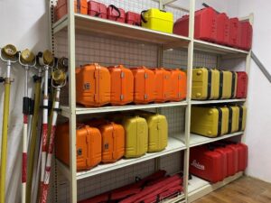
The Geomatics Engineering Department provides a different and effective learning experience through various labs including:
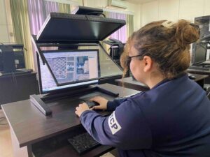
1.The Geomatics Lab:
It’s the main lab of the department that provides different engineering surveying instruments including automatic and digital levels, theodolites, total stations, GNSS systems and receivers, laser scanners,…etc. These instruments are available for students and lecturers for the purpose of land surveying and scientific research.
2. The GIS Lab:
This lab is used for students to get a hands-on experience for the newest technology regarding Geographic Information System (GIS) through using ArcGIS software packages. Students and researchers use the available packages for survey analysis, planning, digitizing, and mapping.
I am text block. Click edit button to change this text. Lorem ipsum dolor sit amet, consectetur adipiscing elit. Ut elit tellus, luctus nec ullamcorper mattis, pulvinar dapibus leo.
3.The Remote Sensing Lab:
This lab is used for the purpose of visualizing and analyzing geographic and environmental data collected by satellites and specialized remote sensors. Students and researchers use the available software packages in the lab to analyze and utilize the data received from remote sensors.
4.Photogrammetry Lab
Is a modern lab that provides innovative technology to students in order to interact and conceptualize the science of photogrammetry. Through various software packages including (Summit Evolution, ERDAS Imagine, Reality Capture,…etc), students get the chance to visualize and analyze arial and satellite images, create 3D models, extract geographic data, and create maps.
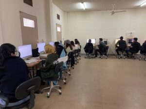
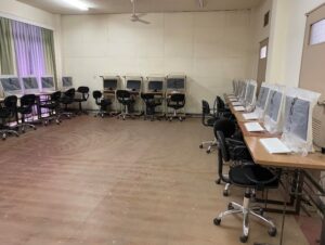
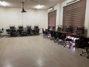
5.The Computer Lab:
The computer lab of the department helps students improve their computer skills through learning the Office Package programs as well as drawing and mapping programs such as AutoCAD and Autoland Civil 3D.
Projects
UAV Experiment in Surveying Engineering Dep. College of Engineering at Salahaddin University Erbil
This project has been achieved in Geomatics (Surveying) Engineering Dep.
Student Projects of 2022/2023
News & Activitis


The seminar held by (Dr. Haval Abdulljabar Sadeq) Instructor and Head of Geomatics and Survey department
دووشەمە رێکەوتی ٢٠١٩⁄٢⁄٤ ئەنجامدانی سیمیناریک لەلایەن بەڕێز(د.ھڤال عبدالجبار صادق)مامۆستا وسەرۆک بەشی ئەندازیاری ڕووپێوان بەمەبەستی بەرزکردنەوەی پلەی زانستی لەمامۆستا بۆ پڕۆفیسۆری یاریدەدەر لەھۆلی سیمینارەکانی بەش.